People fill sandbags to prepare for Hurricane Nate in Moss Point, Miss., on Saturday, Oct. 7, 2017. Storm surge threatens many low-lying neighborhoods in city, which was heavily flooded during 2005's Hurricane Katrina. (AP Photo/Jeff Amy)
The Associated Press
NEW ORLEANS (AP) - Hurricane Nate came ashore on a sparsely populated area at the mouth of the Mississippi River on Saturday and closed in on Mississippi, pelting the central Gulf Coast region with strong winds and heavy rains.
Nate was forecast to make its second landfall near Biloxi, Mississippi, and threatened to inundate homes and businesses.
The center of the storm passed to the east of New Orleans, sparing the city its most ferocious winds and storm surge. And its quick speed lessened the likelihood of prolonged rain that would tax the city's weakened drainage pump system.
The city famous for all-night partying was placed under a curfew, effective at 7 p.m., but the mayor lifted it when it appeared the storm would cause little problems for the city. Still, the streets were not nearly as crowded as they typically are on a Saturday night.
Along the Mississippi coast, cities such as Gulfport and Biloxi were on high alert. Some beachfront hotels and casinos were evacuated, and rain began falling on the region Saturday. Forecasters called for 3 to 6 inches (7 to 15 centimeters) with as much as 10 inches (25 centimeters) in some isolated places.
Nate weakened slightly and was a Category 1 storm with maximum winds of 85 mph (137 kph) when it made landfall in a sparsely populated area of Plaquemines (PLAK'-uh-minz) Parish. Forecasters had said it was possible that it could strengthen to a Category 2, but that seemed less likely as the night wore on.
Storm surge threatened low-lying communities in southeast Louisiana, eastward to the Alabama fishing village of Bayou la Batre.
"If it floods again, this will be it," said Larry Bertron as said as he and his wife prepared to leave their home in the Braithwaite community of vulnerable Plaquemines Parish. The hurricane veterans lost one home to Hurricane Katrina in 2005 and left the home they rebuilt after Hurricane Isaac in 2012.
Governors in Louisiana, Mississippi and Alabama declared states of emergency. The three states have been mostly spared during this hectic hurricane season.
"This is the worst hurricane that has impacted Mississippi since Hurricane Katrina," Mississippi Emergency Management Director Lee Smithson said Saturday. "Everyone needs to understand that, that this is a significantly dangerous situation."
Officials rescued five people from two sailboats in choppy waters before the storm. One 41-foot sailboat lost its engine in Lake Pontchartrain and two sailors were saved. Another boat hit rocks in the Mississippi Sound and three people had to be plucked from the water.
Louisiana Gov. John Bel Edwards urged residents to make final preparations quickly and stressed that Nate will bring the possibility of storm surge reaching up to 11 feet in some coastal areas.
"It's going to hit and move through our area at a relatively fast rate, limiting the amount of time it's going to drop rain," Edwards said. "But this is a very dangerous storm nonetheless."
Streets in low-lying areas of Louisiana were already flooded. Places outside of levee protections were under mandatory evacuation orders and shelters opened there.
Some people worried about New Orleans' pumping system, which had problems during a heavy thunderstorm on Aug. 5. The deluge exposed system weaknesses - including the failure of some pumps and power-generating turbines - and caused homes and businesses to flood. Repairs have been made but the system remained below maximum pumping capacity.
On Alabama's Dauphin Island, water washed over the road Saturday on the island's low-lying west end, said Mayor Jeff Collier. The storm was projected to bring storm surges from seven to 11 feet near the Alabama-Mississippi state line. Some of the biggest impacts could be at the top of funnel-shaped Mobile Bay.
With Nate marching to a second landfall on the Mississippi Gulf Coast, gauges showed tides are 4 feet above normal from Shell Beach, Louisiana, east of New Orleans, to Bayou La Batre, Alabama, southwest of Mobile. In Mississippi, Hancock County Emergency Management Director Brian Adam said his agency received reports of rising water on low-lying streets facing the Mississippi Sound and the Bay of St. Louis. In Biloxi, authorities reported water from Biloxi Bay rising on some streets.
The window for preparing "is quickly closing," Alabama Emergency Management Agency Director Brian Hastings said.
Florida Gov. Rick Scott warned residents of the Panhandle to prepare for Nate's impact.
"Hurricane Nate is expected to bring life-threatening storm surges, strong winds and tornados that could reach across the Panhandle," Scott said. The evacuations affect roughly 100,000 residents in the western Panhandle.
The Pensacola International Airport announced it will close at 6 p.m. Saturday and remain closed on Sunday. However, the Louis Armstrong New Orleans International Airport was open Saturday.
At 11 p.m. EDT Saturday, Nate was about 35 miles (56 kilometers) southwest of the mouth of the Mississippi River. The storm was expected to quickly weaken as it cuts a path through the Southeast on its way to the Mid-Atlantic and Northeast regions, which could see impacts from Nate early next week.
Nate killed at least 21 people after strafing Central America.
In New Orleans, ahead of Saturday night's curfew, some bars were closed in the French Quarter but music blasted from others.
"We're down here from Philly and we're not going to just stay in our hotel room," said Kelly Howell, who was drinking with friends at The Bourbon Street Drinkery.
___
Associated Press writer Kim Chandler in Alabama and Kevin McGill in New Orleans, and AP photographer Gerald Herbert in Plaquemines Parish, contributed to this report.
Gulf Coast waves crash against rocks as winds continue to speed up in Coden, Ala., on Saturday, Oct. 7, 2017, ahead of Hurricane Nate, expected to make landfall on the Gulf Coast later in the day. (AP Photo/Brynn Anderson)
The Associated Press
Boat hand Wayne Hall helps to secure the boat "Jeraline" in Bayou La Batre, Ala., on Saturday, Oct. 7, 2017, ahead of Hurricane Nate, expected to make landfall on the Gulf Coast later in the day. (AP Photo/Brynn Anderson)
The Associated Press
Ray Courterier and his daughter Alicia drink beer at a beachfront bar as Hurricane Nate approaches the Gulf coast in Pensacola Beach, Fla., on Saturday, Oct. 7, 2017. Coastal residents from Louisiana to the Florida panhandle braced for the effects of fast-moving Hurricane Nate, expected to hit sometime Saturday night. (AP Photo/Brendan Farrington)
The Associated Press
The wind from Hurricane Nate pushes waves from the Santa Rosa Sound on Saturday Oct. 7, 2017 across the Navarre Beach causeway in Navarre Beach, Fla.(Nick Tomecek/Northwest Florida Daily News via AP)
The Associated Press
This enhanced infrared satellite image made available by the National Oceanic and Atmospheric Administration shows Hurricane Nate in the Gulf of Mexico on Saturday, Oct. 7, 2017 at 2:15 p.m. EDT. Coastal residents from southeast Louisiana to the Florida panhandle braced for the effects of the fast-moving hurricane, expected to hit sometime time Saturday night. (NOAA via AP)
The Associated Press
Red flags fly at Navarre Beach, Florida indicating that people should not swim in the Gulf of Mexico as Hurricane Nate approaches the Gulf Coast, on Saturday, Oct. 7, 2017. (Nick Tomecek/Northwest Florida Daily News via AP)
The Associated Press
A beachgoer relaxes on Navarre Beach on Saturday Oct. 7, 2017 as Hurricane Nate pushes waves from the Gulf of Mexico against the Navarre Beach Fishing Pier in Navarre Beach, Fla. (Nick Tomecek/Northwest Florida Daily News via AP)
The Associated Press
Workers close the floodgate separating St. Bernard Parish from the East Bank of Plaquemines Parish, in Violet, La., in preparation for Hurricane Nate, expected to make landfall on the Gulf Coast, Saturday, Oct. 7, 2017. (AP Photo/Gerald Herbert)
The Associated Press
Worker close the floodgate separating St. Bernard Parish from the East Bank of Plaquemines Parish, in Violet, La., in preparation for Hurricane Nate, expected to make landfall on the Gulf Coast, Saturday, Oct. 7, 2017. (AP Photo/Gerald Herbert)
The Associated Press
Workers close the floodgate separating St. Bernard Parish from the East Bank of Plaquemines Parish, in Violet, La., in preparation for Hurricane Nate, expected to make landfall on the Gulf Coast, Saturday, Oct. 7, 2017. (AP Photo/Gerald Herbert)
The Associated Press
Worker close the floodgate separating St. Bernard Parish from the East Bank of Plaquemines Parish, in Violet, La., in preparation for Hurricane Nate, expected to make landfall on the Gulf Coast, Saturday, Oct. 7, 2017. Strengthening Hurricane Nate is now expected to be a Category 2 hurricane at landfall on the central Gulf Coast in coming hours. (AP Photo/Gerald Herbert)
The Associated Press
The back of a car is filled with bags of sand at the West Bank Bridge Park in Luling as St. Charles Parish, La., residents prepare for Hurricane Nate on Saturday, Oct. 7, 2017. Forecasters say an intensifying Hurricane Nate is now expected to be a Category 2 hurricane at landfall on the central Gulf Coast in coming hours. (Brett Duke/NOLA.com The Times-Picayune via AP)
The Associated Press
St. Charles Parish, La., resident Jarmar Gross, right, holds a bag as a prison trustee fills it with sand at the West Bank Bridge Park in Luling as preparations continue for Hurricane Nate on Saturday, Oct. 7, 2017. Forecasters say an intensifying Hurricane Nate is now expected to be a Category 2 hurricane at landfall on the central Gulf Coast in coming hours. (Brett Duke/NOLA.com The Times-Picayune via AP)
The Associated Press

FILE - In this Friday, Sept. 9, 2016, file photo, Louisiana Gov. John Bel Edwards testifies in on Capitol Hill in Washington, before the House Oversight and Government Reform subcommittee on Transportation and Public Assets hearing on FEMA's response to the flooding in Baton Rouge, La. Strengthening Tropical Storm Nate is sending U.S. Gulf Coast residents scrambling to prepare as hurricane warnings covered the region. Louisiana's Gov. Edwards urged his state's residents to take Nate seriously Friday, Oct. 6, 2017, saying the storm "has the potential to do a lot of damage." (AP Photo/Molly Riley, File)
The Associated Press
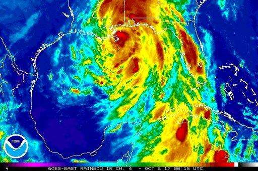
This enhanced infrared satellite image made available by the National Oceanic and Atmospheric Administration shows Hurricane Nate approaching the mouth of the Mississippi River on Saturday, Oct. 7, 2017 at 8:15 p.m. EDT. Nate came ashore at the mouth of the Mississippi River on Saturday and pelted the central Gulf Coast with wind and rain as the fast-moving storm steamed toward the Mississippi coast, where it was expected to make another landfall and threatened to inundate homes and businesses in vulnerable low-lying areas. (NOAA via AP)
The Associated Press
Hours before Hurricane Nate was forecast to hit the Mississippi Gulf Coast, residents visit a pier in Biloxi, Miss., to look at the swells before nightfall, as the outer bands of the hurricane begin to batter the shore, Saturday, Oct. 7, 2017. (Justin Vicory/The Clarion-Ledger, via AP)
The Associated Press
An abandoned boat takes on water on the Mississippi Gulf Coast, Saturday, Oct. 7, 2017, near Biloxi, Miss., as the outer bands of Hurricane Nate begin to batter the shore. (Justin Vicory/The Clarion-Ledger via AP)
The Associated Press